
A severe cold wave has intensified across North India, with Delhi recording its lowest temperature of the season. Rajasthan experienced sub-zero temperatures, and several states have issued alerts and closed schools due to the extreme conditions.

Delhi recorded its coldest January morning in three years with the minimum temperature dropping to 3 degrees Celsius. Cold wave conditions are expected to persist, and air quality has deteriorated to the 'very poor' category.

The maximum temperature at the Safdarjung Observatory, Delhi's base station, rose to 42.5 degrees Celsius.

The India meteorological department said another western disturbance is likely to bring storms and rain to the northern plains, including Delhi, over the next few days.

The maximum temperature on Saturday settled at 18.1 degrees Celsius, two notches below the season's average, and the minimum was recorded at 3.6 degrees Celsius, four notches below the season's average, the IMD said.

Such weather conditions are not typical for May which tends to be the hottest month of the year in Delhi with a mean maximum temperature of 39.5 degrees Celsius.

Cold-day conditions prevailed in parts of north India on Friday though the maximum temperatures rose slightly amid clear skies and sunshine during the day.

The weather department also said the national capital recorded only two rainy days this May, the lowest in 10 years.

Very dense fog lowered visibility to 50 metres at the Palam observatory, near the Indira Gandhi International airport, at 5:30 am.

Around 29 trains have been delayed by two to five hours due to foggy weather, a railway official said.

The Met Office has issued a yellow alert, warning of moderate rain which could cause more problems to the residents of Delhi.

The Met department blamed the malfunctioning of sensors kept at the Automated Weather Station for the gaffe.
Some of the stretches and areas where waterlogging was seen included Dhaula Kuan, Mathura Road, Moti Bagh, Vikas Marg, Ring Road, Rohtak Road, Sangam Vihar, Kirari and near Pragati Maidan among others.

Mercury breached the 45 degree Celsius mark on Friday in the national capital, a day after the city witnessed the hottest day of the season with the maximum temperature being recorded at 44.7 degree Celsius.

The Safdarjung Observatory, which provides representative data for the city, recorded a maximum temperature of 40.1 degrees Celsius, which was eight notches more than normal, said Kuldeep Srivastava, the head of the IMD's regional forecasting centre.

Delhi sweltered under intense heat as the Safdarjung observatory, considered the official marker of the national capital, noted a high of 43.8 degrees Celsius, four notches above the normal average.

The mercury soared to 46.2 degrees Celsius at Najafgarh, making it the hottest place in the capital.

The Mungeshpur weather station recorded a high of 48.8 degrees Celsius, eight notches above the normal. It recorded a minimum temperature of 27.6 degrees Celsius, a notch above the season's average.

The India meteorological department has issued a yellow alert, warning of a fresh heatwave spell in Delhi which may see temperatures soaring to 44 degrees Celsius by Wednesday.

It said Delhi is facing an unprecedented heatwave with temperatures hovering around 50 degrees Celsius in some parts for the first time in the city's history.

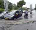
Delhi on Saturday witnessed heavy traffic jams with water-logging on several busy intersections leaving motorists stuck on the streets.

Officials sought to downplay the incident saying the convoy was not stuck but had only slowed down due to heavy traffic and rainfall.

A punishing cold wave swept Delhi on Monday morning with the minimum temperature at the Safdarjung observatory, the city's base station, plunging to 1.4 degrees Celsius, the lowest in the month since January 1, 2021.

The India Meteorological Department (IMD) said parts of South Delhi reported hailstorm around 7.30 am. More rain and hailstorms are predicted during the day, it said.

The national capital has been witnessing an incessant spell of light to moderate rain for the past two days.

The Ayanagar weather station recorded 122.8 mm between 8.30 am on Wednesday and 8.30 am on Thursday, which was 11 times the normal rainfall.
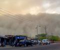
A high-velocity dust storm hit the national capital and regions of Haryana and Rajasthan. The storm, with a wind speed of 70 kilometres per hours, hit Delhi around 11.20 pm on Monday, an official at the Safdarjung observatory said. Here's a glimpse of the storm and all that it brought along with it.

The mercury at the Safdarjung Observatory is expected to breach the 43-degree mark on Thursday and touch 44 degrees Celsius by Friday, according to the India meteorological department.

The India Meteorological Department has issued an 'orange' alert.
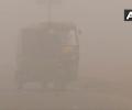
This is the third time this season, after December 8 and January 1, that visibility has dropped to zero metres in the city.

According to the MeT department, the Safdarjung Observatory recorded 23.2 mm rainfall while Palam recorded 35.8 mm rainfall between 8.30 am and 5.30 pm.

Dense to very dense fog prevailed in some parts of the National Capital Region (NCR), Haryana, Punjab, west Uttar Pradesh and north Rajasthan on Tuesday.

A railway official said around 20 trains were delayed by 15 minutes to 2 hours in the morning.
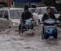
Heavy rains kept the temperature below normal levels on Saturday even as waterlogging in several areas slowed vehicular movement inconveniencing commuters in the national capital.

A severe cold wave brought the minimum temperature down to a numbing 1.5 degrees Celsius at the Ridge weather station in central Delhi.

Delhi recorded a cold wave for the second consecutive day on Friday, with the minimum temperature at Ayanagar in southwest Delhi plunging to a numbing 1.8 degrees Celsius.

Northwest, central and east India are predicted to record maximum temperatures three to five degrees above normal over the next five days, the India meteorological department (IMD) said on Thursday.

The maximum temperature at the Safdarjung Observatory, Delhi's base station, is likely to rise to 45 degrees Celsius.

The India Meteorological Department (IMD) predicted that cold wave to severe cold wave conditions are very likely to continue in northwest India over the next three days and abate thereafter.

The city also recorded a maximum temperature of 23.8 degrees Celsius, 16 notches below normal and the lowest in the month of May since 1951, the IMD said.